Lainz Tunnel, LT 31 Contract Section
Client: Austrian Railways Infrastructure AG
Development Period: 1991 to 2010
The LT 31 contract section of the railway link between the Western, Southern and Donaulände Railway Line in Vienna (Lainz Tunnel) comprises a double tracked tunnel with a length of 3050 m in closed coverage type. The tunnel runs partly below an operating railway track and partly below city structures. The excavation started from two vertical shafts, in each case in both directions. The overburden varies from 6 m to 26 m.
The structure is situated in Miocene sediments of the Vienna Basin. The material can be described as a succession of sand, locally also gravel, silt-clay, as well as zones of sandstone and conglomerate. Ground water is found in several bearing layers at a pressure level of up to 10 m above tunnel crown.
BGG Consult worked for the project in the fields of geology, geotechnics and geohydrology immediately after the time the route was chosen until the completion of construction. Based on subsoil explorations, geotechnical and geohydrological expert's reports have been compiled.
During construction, consulting with regard to geology, geohydrology and geotechnics was carried out. Moreover, the implementation and evaluation of inclinometer measurements as well as the supervision of ground water lowering measures was within the scope of work. Furthermore, BGG Consult was commissioned for the geological documentation of the shafts and the tunnel.
Ground Water Lowering Measures:
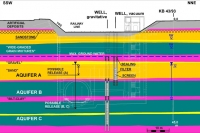
In order to grant a stable subsoil situation in the vicinity of the tunnel and the shafts, the water bearing layers had to be dewatered and the pressure relieved respectively. The ground water drawdown was achieved mostly by vertical wells from above ground. For the design of the wells, i.e. the determination of the location of the well screen, the slot width and the well system (gravitative or vacuum), the stratification of the subsoil and the different water bearing layers had to be scrutinized. A total of 120 vertical wells with depths of up to 50 m were built.
Residual water and local water bearing layers were captured by drainage pipes (driven or placed in boreholes, with or without vacuum) during excavation and tunnel advance respectively.
The monitored data (flow rates, water level in ground water gauges) were read automatically and could be accessed online in real-time.
August 2010
