B14 Klosterneuburg Road,
Klosterneuburg By-Pass
Client: Provincial Government of Lower Austria
Development Period: 2003 to 2009
By relocating the B14 road, with a length of 3.6 km, to the eastern side of the Franz-Josefs Railway Line, the city centre of Klosterneuburg was relieved of transit traffic. Moreover, the road connection to the new industrial areas has been improved.
One requirement of the project was that the access routes be kept open to the extended recreation areas along the Danube. This made the construction of three tunnels along the project necessary. In addition to this, the project included the construction of seven bridges. One of the bridges, with a length of 220 m, had to be constructed on terrain with a steep slope.
The design included special challenges, such as the vicinity of the Danube and the Klosterneuburger Durchstich (subject to the possibility of flooding), and the necessity of multiple crossings of the highly used Franz-Josefs Railway Line.
BGG Consult has been involved in the project since spring 2003, when the authorities required additional geological and hydrogeological investigations.
Based on the results of previous subsoil explorations and additional surveys, an expert's report was compiled regarding the geology and hydrogeology of the project site. Furthermore, a report was prepared concerning the numeric groundwater model calculations.
During the tender preparation phase, a geotechnical expert's report was compiled based on another subsoil exploration campaign and on the final design of the project.
During construction, geological, hydrogeological and geotechnical consultation was provided.
Trough structures:
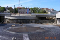
Due to the high groundwater level, the three tunnels along the route required trough structures with lengths of up to 500 m. Near the southern end of the project, a whole roundabout including its ramps is situated below groundwater. In order to control the uplift, a heavily reinforced bottom plate was necessary (see photo).
From an ecological point of view, it had to be guaranteed that the groundwater stream would not be interrupted by the structure. The latter would have resulted in a negative impact on the hydrogeological situation and the ground water wells. Consequently, extensive groundwater communication measures were planned and implemented based on numeric groundwater model calculations.
December 2007
