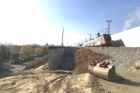
Two-Track Extension of the Pottendorf Railway Line, Hennersdorf - Wampersdorf Section
Client: Austrian Railways Infrastructure AG
Development Period: 2006 to 2021
In the European context, the Southern Railway Line is an important part of the trans-european route between the Baltic Sea and the Adriatic Sea. Since the main line between Vienna-Meidling and Wr. Neustadt is almost at the limit of its capacity, the parallel running Pottendorf Line is being developed into a complete two-track line.
The 13.4 km long project section between Hennersdorf and Münchendorf included - besides extensive earthworks - the new construction of three railway stations (one of them at a raised level), 23 new bridges and underpasses, 11 km noise protection walls and drainage facilities.
BGG Consult attended to this project since the beginning of the procedure pertaining to railway law (including environmental impact assessment) in all geotechnical and hydrogeological matters. For this, an underground investigation campaign was planned, supervised and evaluated in the year 2006. Based on the results, the Environmental Report and the expert's report regarding geotechnics and hydrogeology have been prepared.
During tendering of the different contract sections, geotechnical reports were compiled for each section, based on supplementary subsoil explorations.
During construction, the works were supervised in the fields of geotechnics and hydrogeology. Also, the preservation of evidence with regard to hydrology was carried out, which also included the flood alarm system.
Raised Level of the Hennersdorf Station:
The new level of the Hennersdorf Station is situated 7 m above the adjacent ground surface. For reason of space, the embankment is protected in this area by retaining walls at both sides. For a continuous operation of the old line at ground level, one track was first built at the raised level and put into operation. Afterwards, the remaining part of the station was completed in several construction phases. The retaining walls hold a deep foundation by means of bored piles, which are integrated in the Neogene and quaternary gravel respectively.
Hydrogeological Preservation of Evidence and Flood Alarm:
Because of the impact of drainage measures on private groundwater wells, a weekly monitoring of numerous ground water measuring points has been stipulated by the authorities. For this, 80 groundwater gauges and wells were equipped with radio-operated automatic measuring devices, which were integrated into an online platform. Thus, all project members had up-to-date access to the ground water data. Furthermore, 12 radar measuring points were established at surface waters and integrated into the system. In addition to the update of the online data, an alarm by text message was sent when limit values were exceeded.
May 2021
